

On busy job sites, you don’t have hours to wait for updates. That’s why drone services for construction companies are now essential: they deliver fast, accurate, high-resolution site data so teams work safer, make decisions sooner, and keep schedules on track.
From Clipboards To Cloud Maps
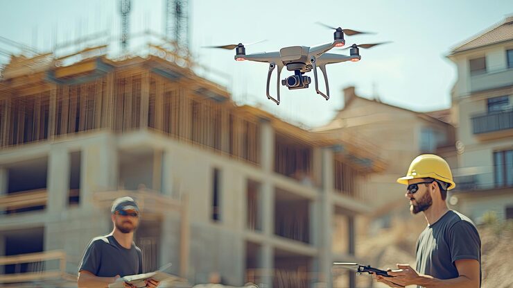
Old methods needed ladders, tapes, and lots of people in risky places. Drones flip that script. They fly a safe route over the site, capture hundreds of overlapping photos, and turn them into a living, measurable map you can open in a browser. You see the whole site at once without confusion about data.
8 Benefits of Drones in Construction (you’ll notice right away)
1) Safer inspections
Roofs, edges, towers, scaffolds drones check them without putting anyone at height. That leads to fewer risky climbs, fewer incidents, and safer days.
2) Faster, accurate surveying
Construction drone mapping uses photogrammetry (and, if needed, LiDAR) to create precise site models. Usually, this flight takes minutes and can replace hours of traditional surveying and still give you distances, areas, elevations, and volumes you can measure.
3) Real-time progress tracking
Weekly (or even daily) flights give you side-by-side updates so you can change plans and avoid sudden problems, spot errors early, and send clients clear progress reports that reduce back-and-forth.
4) Better quality control
Drones help to compare the design to reality on screen and catch misaligned utilities, wrong elevations, or missing materials before they turn into rework.
5) Stockpiles and quantities in a click
If you need to check how much sand or soil you have on-site, a drone can measure it quickly and precisely. That means no more guessing and no billing mix-ups later.
6) Site security and awareness
When the site is closed, a drone can do a quick flyover even at night and save video with timestamps. It discourages trouble and gives you evidence if anything goes wrong.
7) Stronger marketing and documentation
Drone photography shows your construction project from a whole new angle, stunning visuals for proposals, social media, and handovers, all from real work, not stock shots.
8) Lower costs, cleaner schedules
Drones cut down extra site visits, speed up approvals, and keep measurements accurate. The result? Projects move quicker, and your margins stay strong.
How drone surveying works
First, a pilot plans a flight route over your site. The drone then captures a series of overlapping photos from above. Those images are uploaded to the cloud, where software turns them into a detailed, to-scale map and 3D model. From there, teams can measure distance, area, or volume and share the results instantly with everyone involved. It’s basically like exploring your project in Google Maps, only this time, the measurements are accurate enough for construction.
Speed and efficiency that save your schedule
Drones can map big sites in minutes, not hours. If plans change during the week, just send the drone up again for updated data. You’ll spot mistakes early, like uneven ground or pipes in the wrong place, before they become expensive fixes. Over time, these small time savings keep your project on schedule and your profits steady.
Safety, regulations, and responsibility
Commercial drones operate under specific local rules, like FAA Part 107 in the U.S. That means only licensed pilots can fly, with proper permissions and safe flight paths that avoid restricted areas. Following these rules keeps everyone protected and ensures every inspection is safe, legal, and well-documented without slowing down the crew.
In-house vs. partner: what fits your team?
- In-house program: Best if your company flies often and can invest in pilot training, drone hardware, safety protocols, and data management systems.
- Trusted partner (the right choice for most builders): Certified pilots handle drone inspections, survey-grade mapping, and data delivery, giving you accurate results without creating a whole new department.
- Before hiring, check the essentials: license and insurance, sample deliverables, accuracy method (GCP or PPK), turnaround time, data ownership, and a clear safety plan.
Better collaboration through shared data
When drone data lives in the cloud, everyone from managers to field crews can see the same live map. They can leave notes, track updates, and fix issues together in real time. No more delays or lost emails, just clear, shared information that keeps the whole team moving.
Why Liyana Construction Inc. uses drone technology
We’re builders first, and we use drones to make every project safer, smarter, and more efficient. They help us spot issues early, keep crews protected, and plan with confidence. When the data is clear, the work flows better, and that’s what we aim for on every job.
FAQs
For frequent checks and progress measurements, drone surveying for construction is highly accurate and much faster. For boundary/legal surveys, you’ll still use a licensed land surveyor — many teams combine both.
Yes. They cut repeat site walks, prevent rework, speed up RFIs and approvals, and keep schedules moving. That adds up to real savings.
Weekly flights work well for most projects; complex sites may benefit from twice-weekly during critical phases.
Yes. Drone maps and 3D models live in the cloud. Teams can measure, annotate, and share links from the field or the office.
Drone LiDAR helps in heavy vegetation or when you need detailed ground surfaces beneath tree cover. For open sites, photogrammetry usually delivers more than enough accuracy.